Welcome to the definitive tool for planning your adventure on the most spectacular Greenway in Asturias. At lasendadeloso.es, we don't just tell you what the route is like; we give you the technical tools so you can enjoy it without surprises.
Click to enlarge or use the download button below to obtain the high-resolution version.
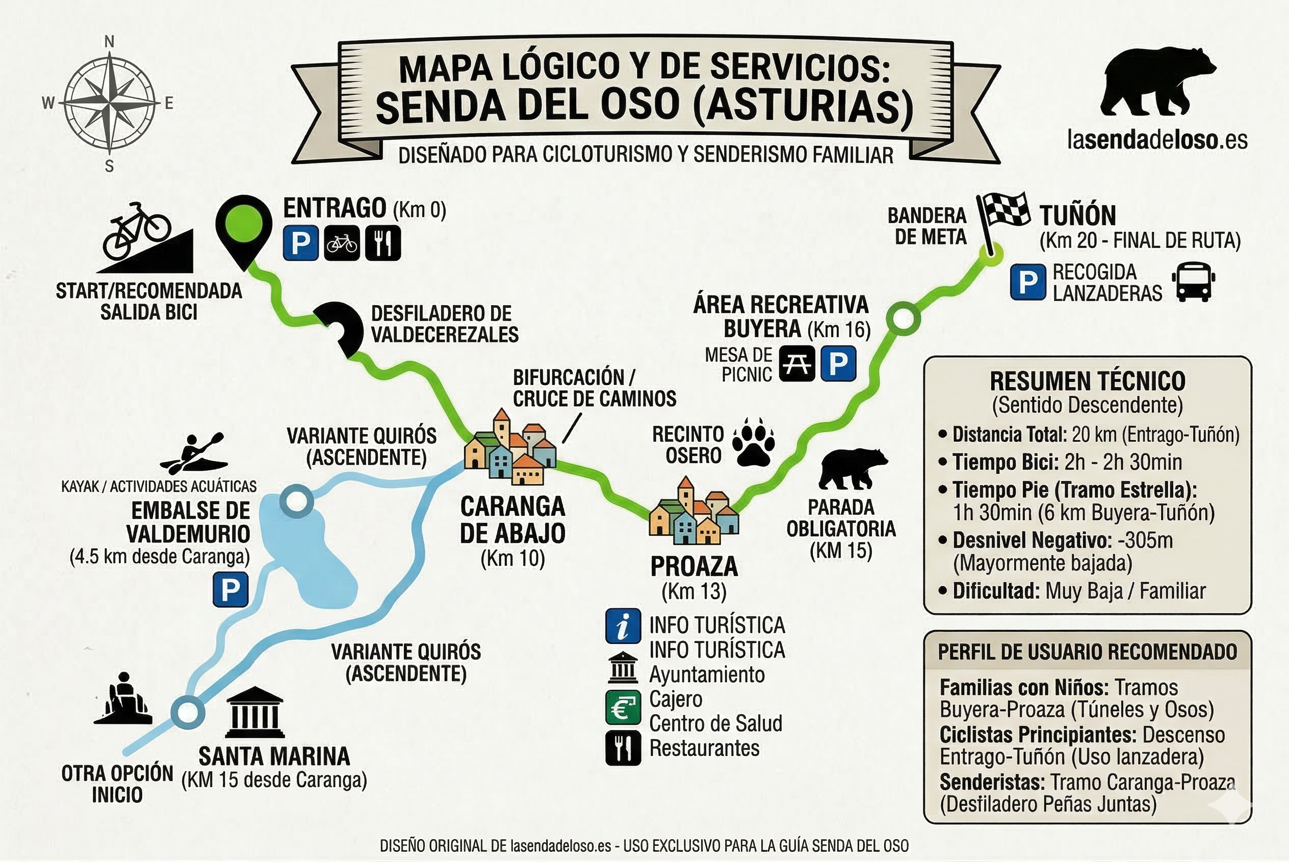
Our Bear Trail Logical and Service Map is an original production, designed by experts in cycling and family hiking, which synthesizes all the logistical complexity of the Trubia valleys into an intuitive and highly useful graphic. Forget imprecise artistic maps; this is your dashboard for the perfect day.
Why is this Bear Trail Map Different?
This map has been created with a visual usability methodology to instantly answer the questions every visitor asks: Where do I start? Which section is easier? Where are there car parks and restaurants?
1. Intelligent Slope and Direction Planning
- Recommended Downhill Direction: We visually identify the downhill profile from Entrago or Santa Marina towards Tuñón. This is the secret to traveling the more than 20 km of the path with minimum effort, ideal for families and casual cyclists.
- Semantic Segmentation of the "Y": We clarify the fork at Caranga de Abajo (Km 10), separating the Teverga Variant (Green) and the Quirós Variant (Blue), so you can choose the landscape you most desire: vertical gorges or the serenity of the reservoir.
2. Structured Technical Data and User Profiles
Integrated directly into the design, our data panels offer you:
- Visual Technical Data: Total distance (20 km), estimated times by bike (2h - 2h 30min) and on foot, negative slope (-305m) and confirmation of Very Low Difficulty.
- User Profile Recommendation Guide: We tell you exactly which section suits you:
- Bear Trail for Kids: Buyera-Proaza sections (with bears and tunnels).
- Bear Trail for Beginners: Entrago-Tuñón descent using a shuttle.
- Key Hiking Sections: Peñas Juntas Gorge (Caranga-Proaza).
3. Iconography and Local Service SEO
The map uses modern and clean icons to accurately locate:
- Car Parks (P), Bike Rentals, Restaurants, Tourist Info: Associated with areas like Entrago, Proaza, Valdemurio, Buyera, and Tuñón.
- Key Landmarks: Exact location of the Bear Enclosure (Km 15), the Valdemurio Reservoir (with kayak icon) or the mining headframe, so you don't miss a thing.
Download the Bear Trail Map in PDF
This map is an original tool of lasendadeloso.es and is protected by copyright. We invite you to use it to plan your trip and to download it in high-resolution PDF format to take with you during the route. It is the perfect complement to our web guide and guarantees you a safe and enriching experience in the Asturias Natural Paradise.
Get your Map + Complete Guide!
Leave us your email and we will send you the high-resolution map (PDF) and our exclusive pocket guide.
We promise not to send spam. Only useful information about the Senda del Oso.